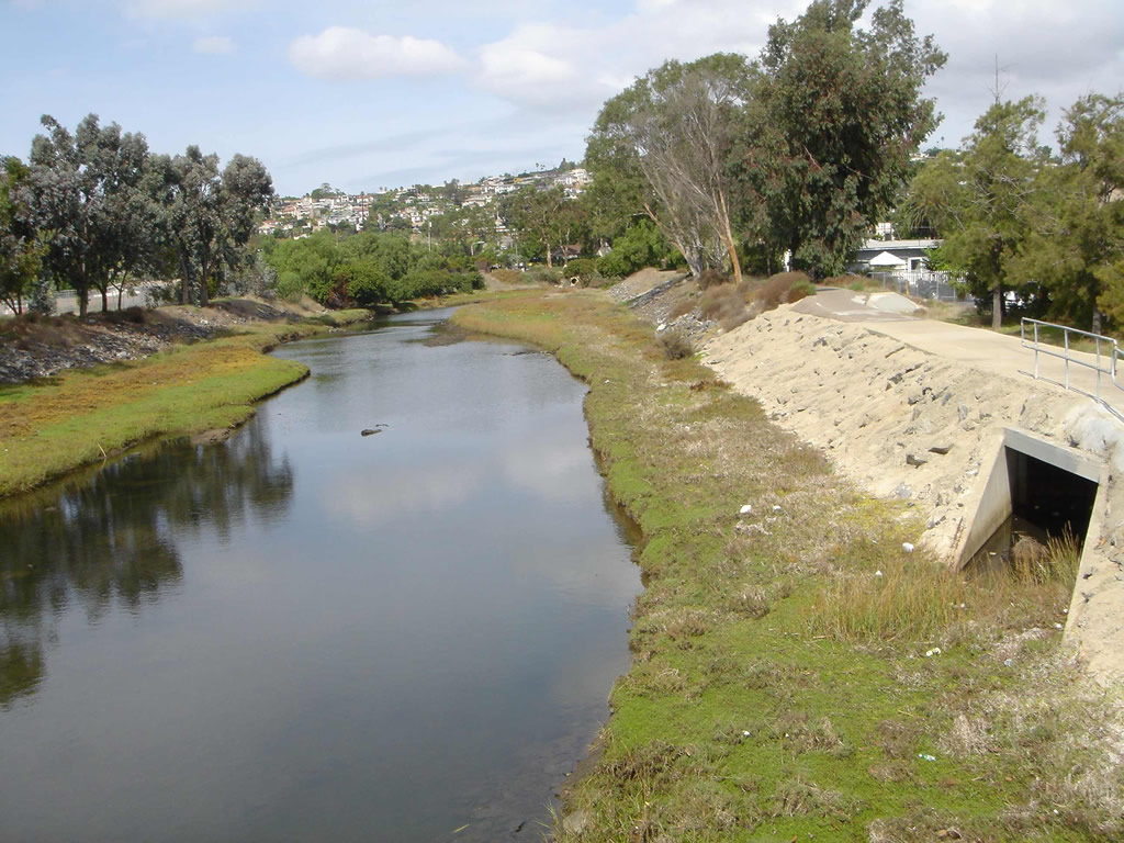
About > Water Quality

Water is the lifeblood of a watershed. Its drainages and streams are the circulation system that not only transports water, but also nutrients, sediments, and pollutants that can both enrich and degrade natural resources as they are transported downstream.

Water enters the Rose Creek Watershed in two primary ways; from the sky as the watershed captures rain after a storm; and through the storm drain system, which directs storm water and dry weather runoff from the city’s streets through a system of pipes to the creeks and eventually to Mission Bay. In carrying water from the upper reaches of MCAS Miramar to Mission Bay, San Clemente and Rose creeks support the plants and animals that the public enjoys in Marian Bear Memorial Natural Park, Rose Canyon Open Space Park and Mission Bay Park, creating an oasis of nature adjacent to urban development. Water in this manner moves native seeds through the watershed allowing more urbanized areas downstream to benefit from the rich biodiversity upstream on MCAS Miramar.
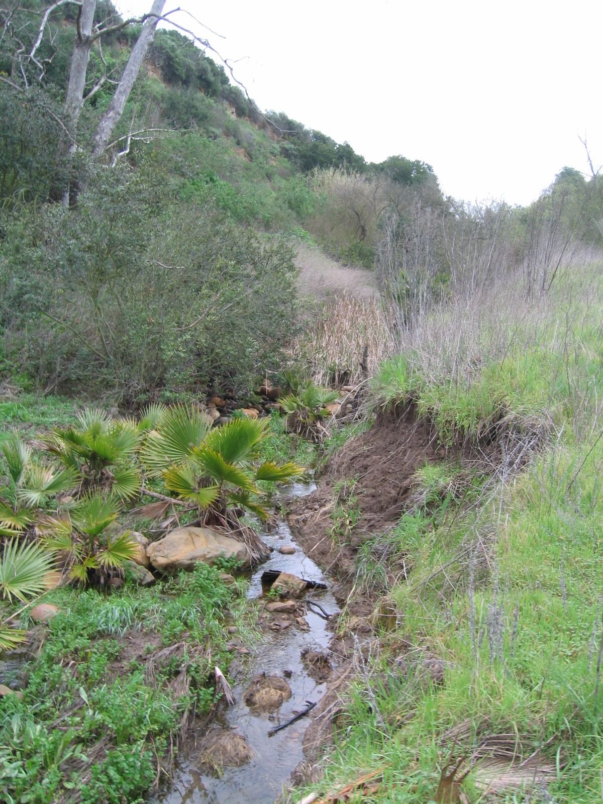
That same enriching water can degrade natural resources and threaten public safety if it moves too fast through the watershed or moves at a volume greater than the creeks and storm drain system can support. Problems include erosion that can undermine the natural flow of a stream, “down-cutting” the banks to destroy trails and natural features and create public safety concerns for hikers and cyclists. In addition, when a stream is down-cut the water is often transported in a much narrower channel, no longer spreading across the land to nurture adjacent riparian plants and animals.

Water can also transport matter detrimental to the health of the watershed including invasive and exotic seeds such as Pampas Grass that can take over entire canyons and out-compete native plants, thus making the watershed less able to support native wildlife. Water also transports pollutants, causing our creeks to be unhealthy and beaches to be closed.


Flood Control


There are roughly 4,276 feet of concrete-flood
channel in the Rose Creek Watershed.
Photo: San Diego Earthworks

Flooding is a natural process that occurs to varying degrees on a somewhat regular basis and typically only presents a problem when larger events present public health and safety concerns or threaten public infrastructure or private property. The relatively small size of the Rose Creek watershed and the fact that most of the upper watershed within MCAS Miramar is still undeveloped has allowed most of the Rose Creek stream network to remain in a natural state with limited areas protected by structural flood control facilities. Most of the structural ‘improvements’ are limited to the western third of the watershed and mainly occur within the upper and lower Rose Canyon. The improvements are primarily comprised of flood channels with concrete sides and natural bottoms, but fully concrete-lined channels near major transportation routes, such as I-805, SR-52, I-5, and West Mission Bay Drive.

As a result of the risk to public infrastructure and private property, the US Army Corps of Engineers and California Department of Water Resources conducted a hydrologic study of Rose and San Clemente drainages in 1972 that mapped 100-year and 500-year floodplains. These floodplains have been incorporated into the Federal Emergency Management Agency (FEMA) Flood Insurance Rate Map (FIRM) for the area and depict 288 acres of land within the 100 year floodplain and another 325 acres of land with undetermined flooding potential.

The 1972 study and resultant mapping products did not delineate the 100-year or 500-year floodplains within MCAS Miramar. The US Army Corps of Engineers did complete a Planning Level Delineation of Aquatic Resources, Floodplain Mapping, and Functional Assessment of Riparian Ecosystems at MCAS Miramar in 2001 that identified a little over 900 acres within the Base boundary in Rose Canyon and a little less than 2,200 acres within San Clemente Canyon as being within the 100 year floodplain. The US Army Corps of Engineers has recently completed a more detailed floodplain assessment for MCAS Miramar.

Water Quality


Mission Beach is closed when waters are contaminated.
Photo: San Diego Earthworks

It is important to understand the condition of California’s coastal waters has degraded over time. With the inception of state-wide water quality testing standards and public disclosure laws, California is now able to accurately measure and fully disclose the condition of recreational waters to residents. And, with the data gathered from testing, municipalities and other agencies are working hard to develop long-term collaborative strategies to minimize the impacts of urbanization on our beaches, bays and watersheds.

Unfortunately, our beaches and bays, including Mission Bay, continue to be closed too often as a result of pollutant levels that are too high. (link to p3w_beachclosures) The County of San Diego Department of Environmental Health (DEH) has an e-mail distribution group for press releases about water quality. For the Recreational Water Program, a press release (Link to p3w_water_e-mail_list) is sent any time a sewage spill impacts any ocean or bay recreational waters, or significant rain causes urban runoff contamination. While there is no separate list for Mission Bay, the information is quite helpful. If you would like to join the list contact Clay Clifton at the Department of Environmental Health.

The City of San Diego is primarily responsible for assuring the quality of water of the Rose Creek Watershed. Urban runoff in the storm drain system within the Rose Creek Watershed is characterized as containing some pollutants at measurable levels; pollutants that are commonly found in urban runoff throughout the region.

Review of the storm drain system monitoring data indicates there are elevated levels of total suspended solids (dirt), pesticides, oil and grease and bacteria. These same pollutants are commonly found in urban runoff across the City and region. The City’s Storm Water Pollution Prevention Program is performing visual observations and field screening monitoring at 24 sampling stations around the watershed.


Storm drain into Lower Rose Creek.
Photo: San Diego Earthworks

The purpose of this monitoring is to detect and eliminate illicit connections and illegal discharges into the storm drain system. When tests reveal elevated levels of pollutants, follow up investigations are conducted as soon as possible to identify the source of pollution. Once the source is found, monitoring staff coordinate with the Storm Water Code Enforcement to eliminate the source so that they do not continued to contribute to lower water quality in Rose Creek. The monitoring data is evaluated annually to compare water quality data between the Rose Creek and other watersheds in the City and across the county. This assessment is included in the City of San Diego’s annual Municipal Storm Water Permit report to the San Diego Regional Water Quality Control Board. For more information about the city’s program to improve water quality please see, www.thinkbluesd.org.

Our thanks to Ruth Kolb of the City of San Diego Water Department, KTU&A, the County of San Diego, Department of Environmental Health and the Regional Water Quality Control Board for their help with the information in this section.


| About | Our Plan | Get Involved | News |
| Youth Service Projects | For Teachers | Contact |

Home | Search | Q&A | Site Map |


4079 Governor Drive, #330, San Diego, CA 92122
info@rosecreekwatershed.org